2008年、番組の企画を作るか(福島の事故前にNHKやTV制作会社の方に打診するも実現せず。。。涙)、記事を書こうとして、書き出したメモ書き。
In
2008, I wrote some earthquake and nuke facility related plans for TV
programs ( I consulted with NHK and a TV production company before the
accident in Fukushima. )
すでに、この時に、私はとあるTV制作会社の方にお願いし、TBS報道特集にて、地震と原発の特集プログラムを作ってもらっていたのです。http://takenouchimari.blogspot.com/2020/08/2008.html(のちに東電から制作会社に「事実関係でひとつも間違いはなかった」という電話をもらいました。)
2008年当時、番組を企画するために私は、原発建設反対で最も尽力された地質学者、故・生越忠博士には何十回と会いに行っていたのでした。(博士の情報に基づいた川内原発http://takenouchimari.blogspot.com/2014/03/blog-post_15.html、伊方原発http://takenouchimari.blogspot.com/2013/04/blog-post_14.html、柏崎原発http://takenouchimari.blogspot.com/2013/04/please-stop-insane-japan-from-nuke.htmlの記事も私のブログにあります)
In
2008, I already made a plan for TV program, which was actually
broadcasted. http://takenouchimari.blogspot.com/2020/08/2008.html I
visited Professor Sunao Ogose, the geologist who had been opposing to the
construction of Japanese nuclear power plants for dozens of times for
this. I
REALLY WANTED TO MAKE MORE TV PROGRAMS ESPECIALLY ON NHK TO STOP ALL THE
NUCLEAR POWER PLANTS BEFORE THE 2011 EARTHQUAKE HIT. BUT THE ACCIDENT HAPPENED AND
MAY HAPPEN MORE IN JAPAN AND THE WORLD!
http://takenouchimari.blogspot.com/2014/03/blog-post_15.html
http://takenouchimari.blogspot.com/2013/04/blog-post_14.html
http://takenouchimari.blogspot.com/2013/04/please-stop-insane-japan-from-nuke.html
ああ、私の企画書をNHKやTV制作会社が真面目に見ていたら、東日本大震災の被害だって少しは軽減されていたかもしれないのです。。。
Oh,
God, if NHK and the TV production company took up my plan seriously,
the damage caused by the Great East Japan Earthquake might have been
alleviated. . .
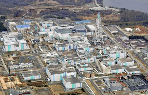
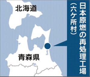
先日驚くべきことに六ケ所再処理工場安全審査が合格となってしまいました。。。
まずはこちらの推進側から出された施設内にある断層の図をご覧ください。
Please look at the Rokkasho Reprocessing facility's site plan submitted by pronuclear side below.
Rokkasho facility is only 30km away from Misawa US Military Base!!!
六ヶ所敷地内に走る2本の断層の恐怖。f-1断層は最大落差140m、f-2断層は最大落差330mと推定されると書いてあるのですが、この落差とは何のことなのだろう。。。これは再処理施設建設申請の準備書面からです。(つまり推進側の文書より)
The fear of two faults running inside the Rokkasho site. The f-1 fault is estimated to have a maximum drop of 140 m, and the f-2 fault is estimated to have a maximum drop of 330 m, but what is this drop? . . These maps are from the preparation document for reprocessing facility construction application. (That is, from the nuclear promotion side)
それと断面図。And the cross section.
日本原燃の再処理工場「合格」 稼働は21年度以降
- 2020/5/13 12:08 日経新聞より

再処理工場の安全対策の基本方針について、11年の東京電力福島第1原発事故後にできた新規制基準に適合していると判断した。今後、一般からの意見公募などを踏まえて、今夏中にも正式に合格が決まる。
原燃は21年度上期までに安全対策など必要な手続きを終える予定で、その後、青森県と六ケ所村の同意を得て稼働にこぎ着けたい考えだ。
原燃の再処理工場は全国の原発で出る使用済み核燃料から再び発電に使えるウランやプルトニウムを商業的に取り出す国内で唯一の施設。100万キロワット級の原発約40基分に相当する年間800トン(ウラン換算)の使用済み核燃料を処理できる能力を持つ。
当初は1997年に完成するはずだったが、トラブルが相次ぎ、これまでに完成時期を24回遅らせた。2006年には最終的な運用試験に入ったものの、不具合対応にてこずっていた11年3月に福島第1事故が起きて、手続きを進められなくなった。
原燃は14年1月に新規制基準に基づく安全審査の申請を出し、規制委は約6年かけて慎重に審査を進めてきた。地震の想定を大幅に引き上げたほか、竜巻に備えて設備を補強した。
重大事故が起きたときの拠点となる緊急時対策所の整備なども進めている。新規制基準の対応前に約2兆2000億円を見込んでいた建設費は、追加の安全対策が必要になり3兆円近くに膨らむ。
再処理工場の完成が遅れている影響で、核燃料サイクルは目詰まりを起こしてきた。再処理工場にある使用済み燃料を貯蔵する施設はほぼ満杯で、電力各社は各原発などでの保管を余儀なくされた。これまでにトラブルを起こし続けてきた施設だけに完成しても、順調に稼働できるかは不透明だ。
また、福島第1原発の事故後に新規制基準に合格して再稼働した原発は全国で9基にすぎない。再処理で生み出した燃料を使う原発が増えなければ、施設の意義も問われかねない。
新型コロナウイルスの感染拡大を防止するため、13日の規制委定例会は一般傍聴者を入れずに審査書案を議論した。従来通りインターネットでは中継したものの、異例の対応だった。
Earthquake and geological problems related to Rokkasho Reprocessing Plant
If you look at the pits of the above faults, you can see the activity in the recent geological age. As a structure, it seems to be a reverse fault formed by the upper plate rising against the lower plate due to some compressive force. (In contrast, Professor Emeritus Kitamura is trying to define tha fault line as a steep slope collapse on a landslide.)
A large fault with a total cliff height of 200 km and a cliff height of 200 meters or more is located in the north-south direction in parallel with the coast east off Aomori Prefecture. If it reactivates fully, it will cause a huge earthquake of M = 8. However, the Japan Earthquake Research Institute and the Japan Atomic Vessel Research and Development Agency deleted the description of this active fault. Furthermore, although the Japan Nuclear Fuel Industries called this large fault as “Sea Area-2 Fault” in the uranium enrichment factory application form, it stated that the fault line were unlikely to be active faults, which was confirmed by Mr. Kinugasa. According to the Kinugasa's minutes, "I was asked by the JNFI to examine the data on active faults in the sea during the uranium examination by the JNFI, but I decided not to do so because the guidelines do not require evaluation up to that level."
ところが、この無視されている大断層に関しては、1667年から1854年までの間にM=6クラスの地震が5回起こっており、また六ヶ所村東方の太平洋海底は1978年の「青森県東岸の地震」(2回のM=5.8の地震)の主震の震央となり、さらに余震の震央は海底から陸地にまたがっており、核燃サイクル基地の近傍にも震央が分布していたという事実により、その地下には正真正銘の活断層が存在する事が明らかである。
However, with respect to this neglected major faults, there were five M = 6 class earthquakes between 1667 and 1854, and the Pacific ocean floor east of Rokkasho Village was in 1978 on the east coast of Aomori Prefecture. Due to the fact that the epicenter of the main earthquake of "Earthquake" (two M = 5.8 earthquakes), and the aftershock epicenter extended from the seabed to the land, and the epicenter was also distributed near the Rokkasho nuclear fuel cycle facility. It is clear that there are genuine active faults underground.
Regarding whether the fault line of Sea Area-2 is active or not, there was a controversy in the "Live TV until Morning" program between Dr. Yuta Suzuki, who was then Director of Research Department of Nuclear Fuel Service, and geologist, Professor. Sunao Ogose (Note: The late Prof. Ogose was the geologist whom Takenouchi used to support and we made a TV program together in 2008 on TBS, Tokyo Broadcasting Station). It was eventually admitted that the May 16, 1978 earthquake was caused by the reverse active fault movement caused by the Sea-2 fault.
Past earthquakes and seismic intensity scales, acceleration, velocity
Based on the "New Japanese Earthquake Damage Survey" (Dr. Tatsuo Usami), Dr. Ogose picked up an earthquake thought to have affected the Pacific coast of Aomori prefecture, and although it reached as many as106, there are earthquakes that were removed from the list by the nuclear industry. For example, the 1677 “Rikuchu earthquake” is one of the worst earthquakes in the Aomori prefecture region, similar to the 1968 Tokachi-oki earthquake considered to be the worst one after WWII, and is absolutely indispensable.
In addition, some seismic intensity levels are lower than those of the Japan Meteorological Agency, even if they are not removed from the list. Although the seismic intensity scale of Rokkasho Village for the Tokachi-oki Earthquake and the "Hidaka, ... Earthquake" is 5, it was written as 4.
The events updated in Usami's old edition (1979) and new edition (1987) are not reflected in the application form. In the 1977 Rikuchu earthquake, the epicenter distance was shortened from 250 km in the old version to 80 km in the new version, but it is not included in Table 3-3 of the application form or the safety review form.
The seismic intensity scale is controlled by the fault distance rather than the epicenter distance, but this is not taken into consideration. Similarly, the depth of the epicenter and the nature of the ground features on the site have a great influence on the seismic intensity, but there is no consideration in that area. (The theory itself is from Professor Ikuei Muramatsu of Gifu University. Nuclear industry still uses M-Δ diagrams. The M-Δ diagrams are useless, looking at the comparison of the 1968 Tokachi-oki Earthquake and 1994 Sanriku Haruka. It is also clear that the seismic intensity scale does not match the measured value and the M-Δ diagram.
During the Sanriku Haruka-oki Earthquake (M = 7.5) on December 28, 1994, a seismic intensity of 6 was observed at Hachinohe with an epicenter distance of 186.5 km, and an earthquake in the northwestern part of Kagoshima Prefecture on May 13, 1997 (M = 6.2), a very large acceleration of 902 gal was observed in Miyanoshiro-machi with an epicenter distance of 18.5 km. Therefore, a large acceleration and a large seismic intensity can be caused by medium-scale earthquakes for the distance that cannot be captured by the Muramatsu type. Even in the case of Rokkasho village.
(1) January 15, 1993 Kushiro-oki earthquake (M = 7.8 h = 101 km), (2) Hokkaido Nansei-oki earthquake (M = 7.8, h = 35 km) on July 12, ③, October 4, 1994 The Hokkaido Toho Oki Earthquake (M = 8.1, h = 23km, ④ The Sanriku Haruka Oki Earthquake on December 28 of the same year, ① and ③ are giant ocean plate-free earthquakes that occurred inside the Pacific rate, and ② is North America. Plate boundary giant earthquake that occurred at the association of the plate and the Eurasian plate, ④ was a large plate boundary type earthquake that occurred at the boundary between the Pacific plate and the North American plate, but Otani Witness was aware of these marine intraplate earthquakes .In addition, although it is sufficient for the operators to assume a seismic intensity scale of 5 on the premises, the first seismic intensity scale 6 was observed in Kushiro in (1) and (3), and the first seismic intensity in Hachinohe ( 4). Floor 6 is observed.
Furthermore, since the Meiji Sanriku earthquake on June 15, 1896 was M = 8.5 due to the tsunami scale, Otani Witness confirmed that the minimum plate boundary earthquake that would occur in the sea near Japan would be at least M = 8.5. I think that we should think about it, and testify that the possibility of an intra-plate earthquake that exceeds M = 8.0 just below the site of the Facility is "conceptually undeniable." ing. If this testimony is quoted as it is, it is reasonable to consider the possibility of impact up to the seismic intensity level 7 on the site, but it is set to 5. However, Otani witnesses said, "There may have been more than 6 earthquakes in the past." (Is seismic intensity 6 or 7 assumed for the secondary design?)
8. Kanai formula-There is no correlation between the magnitude of the calculated maximum velocity amplitude of the site base based on the Osaki method and the magnitude of the actual damage.
9. No reliability of Matsuda
10. For three-dimensional ground motions, it is strange not to calculate acceleration and velocity in ground motions by combining three directions. Why south-south-east-northwest?
About the ground (from "When a large earthquake hits a nuclear fuel facility" on page 61)
1. Although the government has endorsed (where is it?) That the rocks that make up the Takahashi Formation belong to soft rocks, Keiichi Ohtani, Director of the Disaster Prevention Research Department, Science and Technology Agency, testified that it was "very hard." It is based on the fact that the N value is 50 or more excluding the weathered part on the upper surface, but even if the N value is 50 or more, it cannot be said that the rock quality is hard, and the expert of soil and basic engineering also has the N value. There are people who warn that one should not overconfide the utility.
2. It was revealed that there was a clear slip surface on the site of the reprocessing facility, but the witness stated that it was not known at the examination stage.
The earthquake motion is transmitted from the epicenter to the ground, transmitted to the buildings / structures, and finally to the facilities / equipment.The most important thing here is that whether they cause resonance phenomenon or not. (Translator's note: I heard from a GE engineer that this resonance phenomenon was NOT calculated in Fukushima either.) It is about that. In order to investigate this problem, it is essential to clarify each natural period. However, Otani witnesses testified that in the first examination, the proper period was never subject to consideration.
The witness interrogated the proper period of the uranium enriched building and testified that it was "probably a comma for 2 or 3 seconds", but did not test the proper period of the Takachiho layer of the Facility at all. The damage rate is completely different depending on the location due to the relationship between the ground and the proper period of the building, which has already been demonstrated in the 1923 Great Kanto Earthquake. Although not too solid, the support base of the facility belongs to soft rock in terms of geotechnical engineering, it is a rock rather than a soil. Therefore, its proper period should be quite short, which could be a concern about the resonance phenomenon with the facility of the trench structure with a short cycle. However, there is no mentioning of this in the application for the facility. By the way, the proper period is one of the important classification criteria in the classification of the ground due to the revision of the construction example of the Building Standards Act in July 1981.
The facility is located at an altitude of 30m and 3km inland, but there are no tsunami articles in the application form or partial amendments. In the 1896 Meiji Sanriku earthquake, the maximum wave height of 38.2m was recorded at Ryori, Sanriku Town, Iwate Prefecture. In the 1856 "Hidaka, Iburi, Oshima, Tsugaru, Nanbu" earthquake, the tsunami caused the Mabuchi River to flow back up to 11km upstream. It is strange to say that at a location of 30 m above sea level and 3 km inland, the tsunami was not taken into consideration and nothing was considered.


